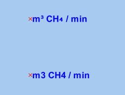
I found the following to work for me. I create a table (using a NVARCHAR2 column for storing the label), then I populate it with two rows: one using the standard label, one using the sub/superscript notation.
create table labels (
id number,
label nvarchar2(30),
geom sdo_geometry
);
insert into labels (id, label, geom)
values (
1,
'm3 CH4 / min',
sdo_geometry (2001, null, sdo_point_type (1,1,null), null, null)
);
insert into labels (id, label, geom)
values (
2,
unistr('m\00B3 CH\2084 / min'),
sdo_geometry (2001, null, sdo_point_type (1,2,null), null, null)
);
commit;
insert into user_sdo_geom_metadata values (
'LABELS',
'GEOM',
sdo_dim_array (
sdo_dim_element ('x', 0, 100, 0.05),
sdo_dim_element ('y', 0, 100, 0.05)
),
null
);
commit;
create index labels_sx on labels (geom) indextype is mdsys.spatial_index;
Mapviewer then nicely renders the super/sub scripts as illustrated!

No comments:
Post a Comment